
New Study Reveals Clues About the Origins of Nepal’s Deadly Flood
Alissa de Chassey Inside Climate News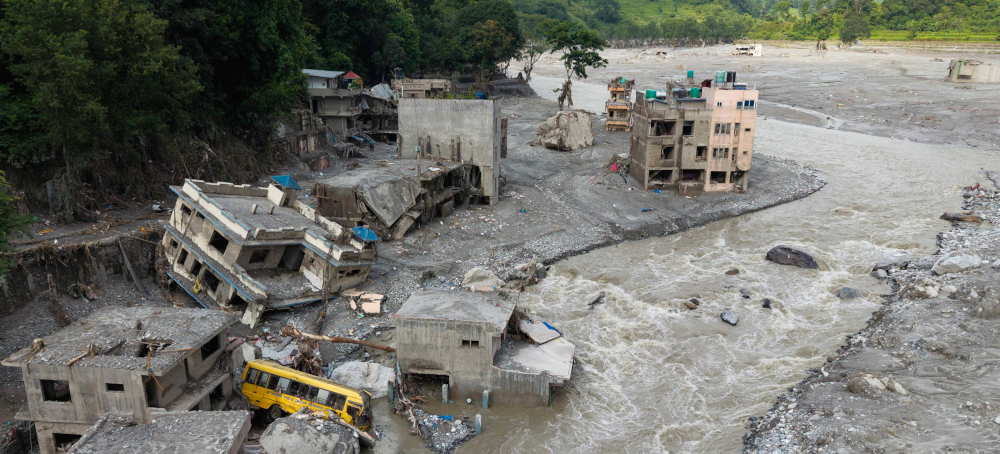 Muddy water surges past houses and through the Trishuli river in the aftermath of flash floods in Nepal’s Nuwakot district on Aug. 29. (photo: Prabin Ranabhat/Getty)
 New Study Reveals Clues About the Origins of Nepal’s Deadly Flood
Alissa de Chassey Inside Climate News
Using seismic data from Nepal and China, researchers identified dozens of small seismic events in the weeks before the August rock-and-ice collapse and ensuing flood.
A massive section of a Himalayan mountainside collapsed near the Nepal-China border, sending millions of cubic meters of rock and ice crashing downhill. The collapse unleashed a devastating flash flood that tore through valleys and communities along Nepal’s Trishuli River. At least 1,455 people were reported dead, and 5,285 remained missing as of Oct.7, according to the Associated Press.
Since this main event, at least two major flooding episodes have happened in the same broader river system, including one on Monday.
To reconstruct the August disaster, the researchers precisely timed the initial mountain collapse. Using data from seismic stations in Nepal and China, they placed the start of the main mass movement at 8:37 a.m., Nepal time.
USGS initially reported a magnitude 4.4 earthquake before realizing it was coming from the landslide itself. Then, Nepalese researchers looked at their records and also reanalyzed the signal, which did not resemble an ordinary earthquake.
“We tried to see the signals, and we didn’t find any earthquake signals,” said Lok Bijaya, chief of the National Earthquake Monitoring and Research Centre in Nepal, and one of the authors of the study.
They found a small magnitude-2.5 seismic event that occurred only about 17 minutes before the catastrophic collapse, less than 10 kilometers away. Although it could have contributed to the slide, “we are not sure the magnitude of 2.5 is enough for this kind of mass failure. It is not clear yet,” said Shiba Subedi, a geophysicist at the Nepal Academy of Science and Technology in Kathmandu, Nepal, and another author of the study.
The researchers detected more than 60 smaller seismic events in the area during the preceding two weeks, including several others in the hours immediately before the collapse.
But “seismic activity doesn’t mean it’s earthquakes,” Bijaya explained. They suggest that at least some of these seismic events may instead have been near-surface “slide-quakes” associated with gravitational movement of the mountainside. In other words, some of those signals could potentially have been the mountain destabilizing before it failed.
But it’s hard to tell how much they contributed to the main event. “Other people are now analyzing and having a closer look,” said György Hetényi, professor of geophysics at the University of Lausanne in Switzerland and another one of the authors. “Given that they’re all clustered in this area, it’s hard to believe it’s not a precursor,” he said.
The collapse itself was so enormous that seismometers around the world detected it. The authors say the seismic amplitudes were actually larger than those from the 2025 Tracy Arm landslide in Alaska.
“The size [of what collapsed] was almost 1.5 kilometers long,” said Bijaya. “It was situated at 5,200 meters, and that mass just dropped down, maybe just slid for 30 seconds, and then dropped down more than a kilometer.” The glacier and rocks sliding created a crater, which now resembles a lake.
Climate change could be part of the story, but it’s likely not the only factor. Changes in ice and glacier movement can alter stresses in the underlying rock and may have contributed to the slope’s instability, Hetényi said.
“Given the amount of rock that has fallen, I think this phenomenon would have happened anyway. Maybe next year if there’s no climate change, or maybe last year, if climate change was more important. But the fall of rock at this volume cannot be only climate change,” he said.
Reconstructing the disaster also exposed another vulnerability in the Himalaya: scientists across the region do not routinely share seismic data.
The lack of available data is a serious issue, the authors said. “It’s creating a very big uncertainty—issues for early warning systems and for locating these kinds of events,” said Bijaya.
For this paper, the team negotiated with Chinese teams and got data they needed the next day. “It was very surprising to me that the Nepalese organized some exchange with the Chinese. That’s great. Usually, it’s not so easy,” said Hetényi.
“That was the first motivation for us, for this paper,” said Bijaya.
India, China and Nepal do not have any protocols to share their data. Because much of the Himalaya is remote and difficult to access, any monitoring is valuable. According to Hetényi, this needs to change.
“I hope this major event will change the view of the politicians, and that they will commit to regional data exchange for monitoring,” he said. “It doesn’t have to be open to the whole wide world.”
Researchers say sharing data would help improve early-warning systems, but the monitoring systems themselves also need to be upgraded.
“If I had plenty of power and money, I would put in water-level measurements, water gauges,” said Hetényi. “I would also use remote sensing, so a satellite-based monitoring system, and I would also use infrasound, which is basically vibration through the air at a lower frequency than we can hear, but that propagates fast enough to give alerts,” said Hetényi.
Subedi said the scientific community must be prepared. “We can have this kind of event many, many times in the future,” he said. “So we have to invest in different kinds of warning mechanisms.”